

| The World Factbook | ||
|
|
Howland Island |
|
|
| Introduction | Howland Island |
|
Background:
|
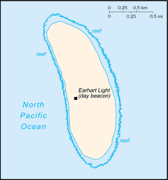
Discovered by the US early in the 19th century, the island was officially claimed by the US in 1857. Both US and British companies mined for guano until about 1890. Earhart Light is a day beacon near the middle of the west coast that was partially destroyed during World War II, but has since been rebuilt; it is named in memory of the famed aviatrix Amelia EARHART. The island is administered by the US Department of the Interior as a National Wildlife Refuge. |
| Geography | Howland Island |
|
Location:
|
Oceania, island in the North Pacific Ocean, about half way between Hawaii and Australia |
|
Geographic coordinates:
|
0 48 N, 176 38 W |
|
Map references:
|
Oceania |
|
Area:
|
total: 1.6 sq km
water: 0 sq km land: 1.6 sq km |
|
Area - comparative:
|
about three times the size of The Mall in Washington, DC |
|
Land boundaries:
|
0 km |
|
Coastline:
|
6.4 km |
|
Maritime claims:
|
territorial sea: 12 nm
exclusive economic zone: 200 nm |
|
Climate:
|
equatorial; scant rainfall, constant wind, burning sun |
|
Terrain:
|
low-lying, nearly level, sandy, coral island surrounded by a narrow fringing reef; depressed central area |
|
Elevation extremes:
|
lowest point: Pacific Ocean 0 m
highest point: unnamed location 3 m |
|
Natural resources:
|
guano (deposits worked until late 1800s), terrestrial and aquatic wildlife |
|
Land use:
|
arable land: 0%
permanent crops: 0% other: 100% (2001) |
|
Irrigated land:
|
0 sq km (1998 est.) |
|
Natural hazards:
|
the narrow fringing reef surrounding the island can be a maritime hazard |
|
Environment - current issues:
|
no natural fresh water resources |
|
Geography - note:
|
almost totally covered with grasses, prostrate vines, and low-growing shrubs; small area of trees in the center; primarily a nesting, roosting, and foraging habitat for seabirds, shorebirds, and marine wildlife |
| People | Howland Island |
|
Population:
|
uninhabited
note: American civilians evacuated in 1942 after Japanese air and naval attacks during World War II; occupied by US military during World War II, but abandoned after the war; public entry is by special-use permit from US Fish and Wildlife Service only and generally restricted to scientists and educators; visited annually by US Fish and Wildlife Service (July 2004 est.) |
| Government | Howland Island |
|
Country name:
|
conventional long form: none
conventional short form: Howland Island |
|
Dependency status:
|
unincorporated territory of the US; administered from Washington, DC, by the Fish and Wildlife Service of the US Department of the Interior as part of the National Wildlife Refuge system |
|
Legal system:
|
the laws of the US, where applicable, apply |
|
Flag description:
|
the flag of the US is used |
| Economy | Howland Island |
|
Economy - overview:
|
no economic activity |
| Transportation | Howland Island |
|
Ports and harbors:
|
none; offshore anchorage only; note - there is one small boat landing area along the middle of the west coast |
|
Airports:
|
airstrip constructed in 1937 for scheduled refueling stop on the round-the-world flight of Amelia EARHART and Fred NOONAN - they left Lae, New Guinea, for Howland Island, but were never seen again; the airstrip is no longer serviceable (2003 est.) |
|
Transportation - note:
|
Earhart Light is a day beacon near the middle of the west coast that was partially destroyed during World War II, but has since been rebuilt; named in memory of famed aviatrix Amelia EARHART |
| Military | Howland Island |
|
Military - note:
|
defense is the responsibility of the US; visited annually by the US Coast Guard |
| Transnational Issues | Howland Island |
|
Disputes - international:
|
none |
|
This page was last updated on 10 February, 2005 |