

| The World Factbook 2002 | ||
|
|
Zimbabwe |
|
|
| Introduction | Zimbabwe |
|
Background:
|
The UK annexed Southern Rhodesia from the South Africa Company in 1923. A 1961 constitution was formulated that favored whites in power. In 1965 the government unilaterally declared its independence, but the UK did not recognize the act and demanded more complete voting rights for the black African majority in the country (then called Rhodesia). UN sanctions and a guerrilla uprising finally led to free elections in 1979 and independence (as Zimbabwe) in 1980. Robert MUGABE, the nation's first prime minister, has been the country's only ruler (as president since 1987) and has dominated the country's political system since independence. |
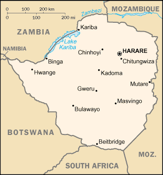
| Geography | Zimbabwe |
|
Location:
|
Southern Africa, between South Africa and Zambia |
|
Geographic coordinates:
|
20 00 S, 30 00 E |
|
Map references:
|
Africa |
|
Area:
|
total: 390,580 sq km
water: 3,910 sq km land: 386,670 sq km |
|
Area - comparative:
|
slightly larger than Montana |
|
Land boundaries:
|
total: 3,066 km
border countries: Botswana 813 km, Mozambique 1,231 km, South Africa 225 km, Zambia 797 km |
|
Coastline:
|
0 km (landlocked) |
|
Maritime claims:
|
none (landlocked) |
|
Climate:
|
tropical; moderated by altitude; rainy season (November to March) |
|
Terrain:
|
mostly high plateau with higher central plateau (high veld); mountains in east |
|
Elevation extremes:
|
lowest point: junction of the Runde and Save rivers 162 m
highest point: Inyangani 2,592 m |
|
Natural resources:
|
coal, chromium ore, asbestos, gold, nickel, copper, iron ore, vanadium, lithium, tin, platinum group metals |
|
Land use:
|
arable land: 8%
permanent crops: 1% other: 91% (1998 est.) |
|
Irrigated land:
|
1,170 sq km (1998 est.) |
|
Natural hazards:
|
recurring droughts; floods and severe storms are rare |
|
Environment - current issues:
|
deforestation; soil erosion; land degradation; air and water pollution; the black rhinoceros herd - once the largest concentration of the species in the world - has been significantly reduced by poaching; poor mining practices have led to toxic waste and heavy metal pollution |
|
Environment - international agreements:
|
party to: Biodiversity, Climate Change, Desertification, Endangered Species, Law of the Sea, Ozone Layer Protection
signed, but not ratified: none of the selected agreements |
|
Geography - note:
|
landlocked; the Zambezi forms a natural riverine boundary with Zambia; in full flood (February-April) the massive Victoria Falls on the river forms the world's largest curtain of falling water |
| People | Zimbabwe |
|
Population:
|
11,376,676
note: estimates for this country explicitly take into account the effects of excess mortality due to AIDS; this can result in lower life expectancy, higher infant mortality and death rates, lower population and growth rates, and changes in the distribution of population by age and sex than would otherwise be expected (July 2002 est.) |
|
Age structure:
|
0-14 years: 37.9% (male 2,178,073; female 2,128,287)
15-64 years: 58.4% (male 3,376,850; female 3,268,315) 65 years and over: 3.7% (male 213,286; female 211,865) (2002 est.) |
|
Population growth rate:
|
0.05% (2002 est.) |
|
Birth rate:
|
24.59 births/1,000 population (2002 est.) |
|
Death rate:
|
24.06 deaths/1,000 population (2002 est.) |
|
Net migration rate:
|
NEGL migrant(s)/1,000 population
note: there is a small but steady flow of Zimbabweans into South Africa in search of better paid employment (2002 est.) |
|
Sex ratio:
|
at birth: 1.03 male(s)/female
under 15 years: 1.02 male(s)/female 15-64 years: 1.03 male(s)/female 65 years and over: 1.01 male(s)/female total population: 1.03 male(s)/female (2002 est.) |
|
Infant mortality rate:
|
62.97 deaths/1,000 live births (2002 est.) |
|
Life expectancy at birth:
|
total population: 36.5 years
female: 35.1 years (2002 est.) male: 37.87 years |
|
Total fertility rate:
|
3.21 children born/woman (2002 est.) |
|
HIV/AIDS - adult prevalence rate:
|
25.06% (1999 est.) |
|
HIV/AIDS - people living with HIV/AIDS:
|
1.5 million (1999 est.) |
|
HIV/AIDS - deaths:
|
160,000 (1999 est.) |
|
Nationality:
|
noun: Zimbabwean(s)
adjective: Zimbabwean |
|
Ethnic groups:
|
African 98% (Shona 82%, Ndebele 14%, other 2%), mixed and Asian 1%, white less than 1% |
|
Religions:
|
syncretic (part Christian, part indigenous beliefs) 50%, Christian 25%, indigenous beliefs 24%, Muslim and other 1% |
|
Languages:
|
English (official), Shona, Sindebele (the language of the Ndebele, sometimes called Ndebele), numerous but minor tribal dialects |
|
Literacy:
|
definition: age 15 and over can read and write English
total population: 85% male: 90% female: 80% (1995 est.) |
| Government | Zimbabwe |
|
Country name:
|
conventional long form: Republic of Zimbabwe
conventional short form: Zimbabwe former: Southern Rhodesia, Rhodesia |
|
Government type:
|
parliamentary democracy |
|
Capital:
|
Harare |
|
Administrative divisions:
|
8 provinces and 2 cities* with provincial status; Bulawayo*, Harare*, Manicaland, Mashonaland Central, Mashonaland East, Mashonaland West, Masvingo, Matabeleland North, Matabeleland South, Midlands |
|
Independence:
|
18 April 1980 (from UK) |
|
National holiday:
|
Independence Day, 18 April (1980) |
|
Constitution:
|
21 December 1979 |
|
Legal system:
|
mixture of Roman-Dutch and English common law |
|
Suffrage:
|
18 years of age; universal |
|
Executive branch:
|
chief of state: Executive President Robert Gabriel MUGABE (since 31 December 1987); Co-Vice Presidents Simon Vengai MUZENDA (since 31 December 1987) and Joseph MSIKA (since 23 December 1999); note - the president is both the chief of state and head of government
head of government: Executive President Robert Gabriel MUGABE (since 31 December 1987); Co-Vice Presidents Simon Vengai MUZENDA (since 31 December 1987) and Joseph MSIKA (since 23 December 1999); note - the president is both the chief of state and head of government cabinet: Cabinet appointed by the president; responsible to the House of Assembly elections: presidential candidates nominated with a nomination paper signed by at least 10 registered voters (at least one from each province) and elected by popular vote; election last held 9-11 March 2002 (next to be held NA March 2006); co-vice presidents appointed by the president election results: Robert Gabriel MUGABE reelected president; percent of vote - Robert Gabriel MUGABE 56.2%, Morgan TSVANGIRAI 41.9% |
|
Legislative branch:
|
unicameral parliament, called House of Assembly (150 seats - 120 elected by popular vote for five-year terms, 12 nominated by the president, 10 occupied by traditional chiefs chosen by their peers, and 8 occupied by provincial governors appointed by the president)
elections: last held 24-25 June 2000 (next to be held NA 2005) election results: percent of vote by party - ZANU-PF 47.2%, MDC 45.6%, ZANU-Ndonga 0.7%, United Parties 0.7%; seats by party - ZANU-PF 63, MDC 56, ZANU-Ndonga 1 |
|
Judicial branch:
|
Supreme Court; High Court |
|
Political parties and leaders:
|
Movement for Democratic Change or MDC [Morgan TSVANGIRAI]; United Parties [Abel MUZOREWA]; Zimbabwe African National Union-Ndonga or ZANU-Ndonga [leader NA]; Zimbabwe African National Union-Patriotic Front or ZANU-PF [Robert Gabriel MUGABE]; Zimbabwe African Peoples Union or ZAPU [Paul SIWELA] |
|
Political pressure groups and leaders:
|
National Constitutional Assembly or NCA [Lovemore MADHUKU] |
|
International organization participation:
|
ACP, AfDB, C, CCC, ECA, FAO, G-15, G-77, IAEA, IBRD, ICAO, ICFTU, ICRM, IDA, IFAD, IFC, IFRCS, ILO, IMF, Interpol, IOC, IOM (observer), ISO, ITU, NAM, OAU, OPCW, PCA, SADC, UN, UNCTAD, UNESCO, UNIDO, UNMIK, UPU, WCL, WFTU, WHO, WIPO, WMO, WToO, WTrO |
|
Diplomatic representation in the US:
|
chief of mission: Ambassador Simbi Veke MUBAKO
FAX: [1] (202) 483-9326 telephone: [1] (202) 332-7100 chancery: 1608 New Hampshire Avenue NW, Washington, DC 20009 |
|
Diplomatic representation from the US:
|
chief of mission: Ambassador Joseph G. SULLIVAN
embassy: 172 Herbert Chitepo Avenue, Harare mailing address: P. O. Box 3340, Harare telephone: [263] (4) 250-593 and 250-594 FAX: [263] (4) 796488 |
|
Flag description:
|
seven equal horizontal bands of green, yellow, red, black, red, yellow, and green with a white isosceles triangle edged in black with its base on the hoist side; a yellow Zimbabwe bird is superimposed on a red five-pointed star in the center of the triangle |
| Economy | Zimbabwe |
|
Economy - overview:
|
The government of Zimbabwe faces a wide variety of difficult economic problems as it struggles to consolidate earlier moves to develop a market-oriented economy. Its involvement in the war in the Democratic Republic of the Congo, for example, has already drained hundreds of millions of dollars from the economy. Badly needed support from the IMF has been suspended because of the country's failure to meet budgetary goals. Inflation rose from an annual rate of 32% in 1998 to 59% in 1999, to 60% in 2000, and to 100% by yearend 2001. The economy is being steadily weakened by excessive government deficits, AIDS, and rampant inflation. The government's land reform program, characterized by chaos and violence, has derailed the commercial sector, the traditional source of exports and foreign exchange and the provider of 400,000 jobs. Distribution of income is extremely unequal. |
|
GDP:
|
purchasing power parity - $28 billion (2001 est.) |
|
GDP - real growth rate:
|
-6.5% (2001 est.) |
|
GDP - per capita:
|
purchasing power parity - $2,450 (2001 est.) |
|
GDP - composition by sector:
|
agriculture: 11%
industry: 14% services: 75% (2000 est.) |
|
Population below poverty line:
|
60% (1999 est.) |
|
Household income or consumption by percentage share:
|
lowest 10%: 1.8%
highest 10%: 46.9% (1990) |
|
Distribution of family income - Gini index:
|
56.8 (1990-91) |
|
Inflation rate (consumer prices):
|
100% (2001) |
|
Labor force:
|
5.5 million (2000 est.) |
|
Labor force - by occupation:
|
agriculture 66%, services 24%, industry 10% (1996 est.) |
|
Unemployment rate:
|
60% (2001 est.) |
|
Budget:
|
revenues: $2.5 billion
expenditures: $2.6 billion, including capital expenditures of $NA (2000 est.) |
|
Industries:
|
mining (coal, gold, copper, nickel, tin, clay, numerous metallic and nonmetallic ores), steel, wood products, cement, chemicals, fertilizer, clothing and footwear, foodstuffs, beverages |
|
Industrial production growth rate:
|
-10% (2001 est.) |
|
Electricity - production:
|
6.425 billion kWh (2000) |
|
Electricity - production by source:
|
fossil fuel: 53.31%
hydro: 46.69% other: 0% (2000) nuclear: 0% |
|
Electricity - consumption:
|
10.475 billion kWh (2000) |
|
Electricity - exports:
|
0 kWh (2000) |
|
Electricity - imports:
|
4.5 billion kWh (2000) |
|
Agriculture - products:
|
corn, cotton, tobacco, wheat, coffee, sugarcane, peanuts; cattle, sheep, goats, pigs |
|
Exports:
|
$2.1 billion (f.o.b., 2001 est.) |
|
Exports - commodities:
|
tobacco 30%, gold 11%, ferroalloys 9%, textile/clothing 3% (2000) |
|
Exports - partners:
|
South Africa 12.1%, UK 8.5%, Japan 7.7%, Germany 6.1%, China 5.4% (2000) |
|
Imports:
|
$1.5 billion (f.o.b., 2001 est.) |
|
Imports - commodities:
|
machinery and transport equipment 34%, other manufactures 18%, chemicals 17%, fuels 11% (1999) |
|
Imports - partners:
|
South Africa 46.3%, UK 7.2%, Germany 2.5%, US 2.8%, Japan 2.5% (2000 est.) |
|
Debt - external:
|
$5 billion (2001 est.) |
|
Economic aid - recipient:
|
$200 million (2000 est.) |
|
Currency:
|
Zimbabwean dollar (ZWD) |
|
Currency code:
|
ZWD |
|
Exchange rates:
|
Zimbabwean dollars per US dollar - 54.9451 (December 2001), 54.9451 (2001), 43.2900 (2000), 38.3142 (1999), 21.4133 (1998), 11.8906 (1997) |
|
Fiscal year:
|
1 January - 31 December |
| Communications | Zimbabwe |
|
Telephones - main lines in use:
|
212,000 (in addition, there are about 20,000 fixed telephones in wireless local loop connections) (1997) |
|
Telephones - mobile cellular:
|
111,000 (2001) |
|
Telephone system:
|
general assessment: system was once one of the best in Africa, but now suffers from poor maintenance; more than 100,000 outstanding requests for connection despite an equally large number of installed but unused main lines
domestic: consists of microwave radio relay links, open-wire lines, radiotelephone communication stations, fixed wireless local loop installations, and a substantial mobile cellular network; Internet connection is available in Harare and planned for all major towns and for some of the smaller ones international: satellite earth stations - 2 Intelsat; two international digital gateway exchanges (in Harare and Gweru) |
|
Radio broadcast stations:
|
AM 7, FM 20 (plus 17 repeater stations), shortwave 1 (1998) |
|
Radios:
|
1.14 million (1997) |
|
Television broadcast stations:
|
16 (1997) |
|
Televisions:
|
370,000 (1997) |
|
Internet country code:
|
.zw |
|
Internet Service Providers (ISPs):
|
6 (2000) |
|
Internet users:
|
30,000 (1999) |
| Transportation | Zimbabwe |
|
Railways:
|
total: 3,077 km
narrow gauge: 3,077 km 1.067-m gauge (313 km electrified; 42 km double-tracked) note: includes the 318 km Bulawaya-Beitbridge Railway Company line (2001) |
|
Highways:
|
total: 18,338 km
paved: 8,692 km unpaved: 9,646 km (2002) |
|
Waterways:
|
chrome ore is transported from Harare - by way of the Mazoe River - to the Zambezi River in Mozambique |
|
Pipelines:
|
petroleum products 212 km |
|
Ports and harbors:
|
Binga, Kariba |
|
Airports:
|
454 (2001) |
|
Airports - with paved runways:
|
total: 17
over 3,047 m: 3 2,438 to 3,047 m: 2 1,524 to 2,437 m: 4 914 to 1,523 m: 8 (2001) |
|
Airports - with unpaved runways:
|
total: 437
1,524 to 2,437 m: 4 914 to 1,523 m: 209 under 914 m: 224 (2001) |
| Military | Zimbabwe |
|
Military branches:
|
Zimbabwe National Army, Air Force of Zimbabwe, Zimbabwe Republic Police (includes Police Support Unit, Paramilitary Police) |
|
Military manpower - availability:
|
males age 15-49: 3,057,381 (2002 est.) |
|
Military manpower - fit for military service:
|
males age 15-49: 1,898,383 (2002 est.) |
|
Military expenditures - dollar figure:
|
$350.6 million (FY01) |
|
Military expenditures - percent of GDP:
|
3.8% (FY01) |
| Transnational Issues | Zimbabwe |
|
Disputes - international:
|
none |
|
Illicit drugs:
|
transit point for African cannabis and South Asian heroin, mandrax, and methamphetamines destined for the South African and European markets |
|
This page was last updated on 1 January 2002 |