


| The World Factbook 2002 | ||
|
|
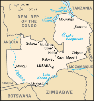
Zambia |
|
|
| Introduction | Zambia |
|
Background:
|
The territory of Northern Rhodesia was administered by the South Africa Company from 1891 until it was taken over by the UK in 1923. During the 1920s and 1930s, advances in mining spurred development and immigration. The name was changed to Zambia upon independence in 1964. In the 1980s and 1990s, declining copper prices and a prolonged drought hurt the economy. Elections in 1991 brought an end to one-party rule, but the subsequent vote in 1996 saw blatant harassment of opposition parties. The election in 2001 was marked by administrative problems with at least two parties filing legal petitions challenging the results. Opposition parties currently hold a majority of seats in the National Assembly. |
| Geography | Zambia |
|
Location:
|
Southern Africa, east of Angola |
|
Geographic coordinates:
|
15 00 S, 30 00 E |
|
Map references:
|
Africa |
|
Area:
|
total: 752,614 sq km
water: 11,890 sq km land: 740,724 sq km |
|
Area - comparative:
|
slightly larger than Texas |
|
Land boundaries:
|
total: 5,664 km
border countries: Angola 1,110 km, Democratic Republic of the Congo 1,930 km, Malawi 837 km, Mozambique 419 km, Namibia 233 km, Tanzania 338 km, Zimbabwe 797 km |
|
Coastline:
|
0 km (landlocked) |
|
Maritime claims:
|
none (landlocked) |
|
Climate:
|
tropical; modified by altitude; rainy season (October to April) |
|
Terrain:
|
mostly high plateau with some hills and mountains |
|
Elevation extremes:
|
lowest point: Zambezi river 329 m
highest point: unnamed location in Mafinga Hills 2,301 m |
|
Natural resources:
|
copper, cobalt, zinc, lead, coal, emeralds, gold, silver, uranium, hydropower |
|
Land use:
|
arable land: 7%
permanent crops: 0% other: 93% (1998 est.) |
|
Irrigated land:
|
460 sq km (1998 est.) |
|
Natural hazards:
|
tropical storms (November to April) |
|
Environment - current issues:
|
air pollution and resulting acid rain in the mineral extraction and refining region; chemical runoff into watersheds; poaching seriously threatens rhinoceros, elephant, antelope, and large cat populations; deforestation; soil erosion; desertification; lack of adequate water treatment presents human health risks |
|
Environment - international agreements:
|
party to: Biodiversity, Climate Change, Desertification, Endangered Species, Hazardous Wastes, Law of the Sea, Nuclear Test Ban, Ozone Layer Protection, Wetlands
signed, but not ratified: Climate Change-Kyoto Protocol |
|
Geography - note:
|
landlocked; the Zambezi forms a natural riverine boundary with Zimbabwe |
| People | Zambia |
|
Population:
|
9,959,037
note: estimates for this country explicitly take into account the effects of excess mortality due to AIDS; this can result in lower life expectancy, higher infant mortality and death rates, lower population and growth rates, and changes in the distribution of population by age and sex than would otherwise be expected (July 2002 est.) |
|
Age structure:
|
0-14 years: 47.1% (male 2,357,581; female 2,335,644)
15-64 years: 50.4% (male 2,497,360; female 2,519,227) 65 years and over: 2.5% (male 106,160; female 143,065) (2002 est.) |
|
Population growth rate:
|
1.9% (2002 est.) |
|
Birth rate:
|
41.01 births/1,000 population (2002 est.) |
|
Death rate:
|
21.89 deaths/1,000 population (2002 est.) |
|
Net migration rate:
|
-0.16 migrant(s)/1,000 population (2002 est.) |
|
Sex ratio:
|
at birth: 1.03 male(s)/female
under 15 years: 1.01 male(s)/female 15-64 years: 0.99 male(s)/female 65 years and over: 0.74 male(s)/female total population: 0.99 male(s)/female (2002 est.) |
|
Infant mortality rate:
|
89.39 deaths/1,000 live births (2002 est.) |
|
Life expectancy at birth:
|
total population: 37.35 years
female: 37.66 years (2002 est.) male: 37.05 years |
|
Total fertility rate:
|
5.43 children born/woman (2002 est.) |
|
HIV/AIDS - adult prevalence rate:
|
19.95% (1999 est.) |
|
HIV/AIDS - people living with HIV/AIDS:
|
870,000 (1999 est.) |
|
HIV/AIDS - deaths:
|
99,000 (1999 est.) |
|
Nationality:
|
noun: Zambian(s)
adjective: Zambian |
|
Ethnic groups:
|
African 98.7%, European 1.1%, other 0.2% |
|
Religions:
|
Christian 50%-75%, Muslim and Hindu 24%-49%, indigenous beliefs 1% |
|
Languages:
|
English (official), major vernaculars - Bemba, Kaonda, Lozi, Lunda, Luvale, Nyanja, Tonga, and about 70 other indigenous languages |
|
Literacy:
|
definition: age 15 and over can read and write English
total population: 78.9% male: 85.7% female: 72.6% |
| Government | Zambia |
|
Country name:
|
conventional long form: Republic of Zambia
conventional short form: Zambia former: Northern Rhodesia |
|
Government type:
|
republic |
|
Capital:
|
Lusaka |
|
Administrative divisions:
|
9 provinces; Central, Copperbelt, Eastern, Luapula, Lusaka, Northern, North-Western, Southern, Western |
|
Independence:
|
24 October 1964 (from UK) |
|
National holiday:
|
Independence Day, 24 October (1964) |
|
Constitution:
|
2 August 1991 |
|
Legal system:
|
based on English common law and customary law; judicial review of legislative acts in an ad hoc constitutional council; has not accepted compulsory ICJ jurisdiction |
|
Suffrage:
|
18 years of age; universal |
|
Executive branch:
|
chief of state: President Levy MWANAWASA (since 2 January 2002); Vice President Enoch KAVINDELE (since 4 May 2001); note - the president is both the chief of state and head of government
head of government: President Levy MWANAWASA (since 2 January 2002); Vice President Enoch KAVINDELE (since 4 May 2001); note - the president is both the chief of state and head of government cabinet: Cabinet appointed by the president from among the members of the National Assembly elections: president elected by popular vote for a five-year term; election last held 27 December 2001 (next to be held NA 2006); vice president appointed by the president election results: Levy MWANAWASA elected president; percent of vote - Levy MWANAWASA 29%, Anderson MAZOKA 27%, Christon TEMBO 13%, Tilyenji KAUNDA 10%, Godfrey MIYANDA 8%, Benjamin MWILA 5%, Michael SATA 3% |
|
Legislative branch:
|
unicameral National Assembly (150 seats; members are elected by popular vote to serve five-year terms)
elections: last held 27 December 2001 (next to be held NA 2006) election results: percent of vote by party - MMD 45.9%, UPND 32.4%, UNIP 8.8%, FDD 8.1%, HP 2.7%, PF 0.7%, ZRP 0.7%, independents 0.7%; seats by party - MMD 68, UPND 48, UNIP 13, FDD 12, HP 4, PF 1, ZRP 1, independents 1; seats not determined 2 |
|
Judicial branch:
|
Supreme Court (the final court of appeal; justices are appointed by the president); High Court (has unlimited jurisdiction to hear civil and criminal cases) |
|
Political parties and leaders:
|
Agenda for Zambia or AZ [Inonge MBIKUSITA-LEWANIKA]; Forum for Democracy and Development or FDD [Christon TEMBO]; Heritage Party or HP [Godfrey MIYANDA]; Liberal Progressive Front or LPF [Roger CHONGWE, president]; Movement for Multiparty Democracy or MMD [Frederick CHILUBA, president]; National Citizens Coalition or NCC [Nevers MUMBA, president]; National Leadership for Development or NLD [Yobert SHAMAPANDE]; National Party or NP [Dr. Sam CHIPUNGU]; Patriotic Front or PF [Michael SATA]; Zambian Republican Party or ZRP [Benjamin MWILA]; Social Democratic Party or SDP [Gwendoline Konie]; United National Independence Party or UNIP [Francis NKHOMA, president]; United Party for National Development or UPND [Anderson MAZOKA] |
|
Political pressure groups and leaders:
|
NA |
|
International organization participation:
|
ACP, AfDB, C, CCC, ECA, FAO, G-19, G-77, IAEA, IBRD, ICAO, ICFTU, ICRM, IDA, IFAD, IFC, IFRCS, ILO, IMF, Interpol, IOC, IOM, ITU, MONUC, NAM, OAU, OPCW, PCA, SADC, UN, UNAMSIL, UNCTAD, UNESCO, UNIDO, UNMEE, UNMIK, UPU, WHO, WIPO, WMO, WToO, WTrO |
|
Diplomatic representation in the US:
|
chief of mission: Ambassador Atan SHANSONGA
FAX: [1] (202) 332-0826 telephone: [1] (202) 265-9717 through 9719 chancery: 2419 Massachusetts Avenue NW, Washington, DC 20008 |
|
Diplomatic representation from the US:
|
chief of mission: Ambassador David B. DUNN
embassy: corner of Independence and United Nations Avenues mailing address: P. O. Box 31617, Lusaka telephone: [260] (1) 250-955 FAX: [260] (1) 252-225 |
|
Flag description:
|
green with a panel of three vertical bands of red (hoist side), black, and orange below a soaring orange eagle, on the outer edge of the flag |
| Economy | Zambia |
|
Economy - overview:
|
Despite progress in privatization and budgetary reform, Zambia's economy has a long way to go. Privatization of government-owned copper mines relieved the government from covering mammoth losses generated by the industry and greatly improved the chances for copper mining to return to profitability and spur economic growth. However, low mineral prices have slowed the benefits from privatizing the mines and reduced incentives for further private investment in the sector. In late 2000, Zambia was determined to be eligible for debt relief under the Heavily Indebted Poor Countries (HIPC) initiative, but Zambia has not yet finalized its Poverty Reduction Strategy paper. Unemployment rates remain high, but GDP growth should continue at about 4%. Inflation should remain close to 20%. |
|
GDP:
|
purchasing power parity - $8.5 billion (2001 est.) |
|
GDP - real growth rate:
|
3.9% (2001 est.) |
|
GDP - per capita:
|
purchasing power parity - $870 (2001 est.) |
|
GDP - composition by sector:
|
agriculture: 24%
industry: 25% services: 51% (2000) |
|
Population below poverty line:
|
86% (1993 est.) |
|
Household income or consumption by percentage share:
|
lowest 10%: 1.1%
highest 10%: 41% (1998) |
|
Distribution of family income - Gini index:
|
52.6 (1998) |
|
Inflation rate (consumer prices):
|
21.5% (2001) |
|
Labor force:
|
3.4 million |
|
Labor force - by occupation:
|
agriculture 85%, industry 6%, services 9% |
|
Unemployment rate:
|
50% (2000 est.) |
|
Budget:
|
revenues: $1.2 billion
expenditures: $1.25 billion, including capital expenditures of $NA (2001 est.) |
|
Industries:
|
copper mining and processing, construction, foodstuffs, beverages, chemicals, textiles, fertilizer, horticulture |
|
Industrial production growth rate:
|
5.1% (2001 est.) |
|
Electricity - production:
|
7.822 billion kWh (2000) |
|
Electricity - production by source:
|
fossil fuel: 0.51%
hydro: 99.49% other: 0% (2000) nuclear: 0% |
|
Electricity - consumption:
|
5.838 billion kWh (2000) |
|
Electricity - exports:
|
1.536 billion kWh (2000) |
|
Electricity - imports:
|
100 million kWh (2000) |
|
Agriculture - products:
|
corn, sorghum, rice, peanuts, sunflower seed, vegetables, flowers, tobacco, cotton, sugarcane, cassava (tapioca); cattle, goats, pigs, poultry, milk, eggs, hides; coffee |
|
Exports:
|
$876 million (f.o.b., 2001 est.) |
|
Exports - commodities:
|
copper 55%, cobalt, electricity, tobacco, flowers, cotton |
|
Exports - partners:
|
UK 25.2%, South Africa 24.5%, Switzerland 9.4%, Malawi 7.5% (2000) |
|
Imports:
|
$12.05 billion (f.o.b., 2001 est.) |
|
Imports - commodities:
|
machinery, transportation equipment, petroleum products, electricity, fertilizer; foodstuffs, clothing |
|
Imports - partners:
|
South Africa 67.1%, UK 9.8%, Zimbabwe 7.5%, US 5.9% (2000) |
|
Debt - external:
|
$5.8 billion (2001) |
|
Economic aid - recipient:
|
$651 million (2000 est.) |
|
Currency:
|
Zambian kwacha (ZMK) |
|
Currency code:
|
ZMK |
|
Exchange rates:
|
Zambian kwacha per US dollar - 3,848.65 (January 2002), 3,610.94 (2001), 3,110.84 (2000), 2,388.02 (1999), 1,862.07 (1998), 1,314.50 (1997) |
|
Fiscal year:
|
calendar year |
| Communications | Zambia |
|
Telephones - main lines in use:
|
130,000 (including more than 40,000 fixed telephones in wireless local loop connections) (1997) |
|
Telephones - mobile cellular:
|
75,000 (2001) |
|
Telephone system:
|
general assessment: facilities are aging but still among the best in Sub-Saharan Africa
domestic: high-capacity microwave radio relay connects most larger towns and cities; several cellular telephone services in operation; Internet service is widely available; very small aperture terminal (VSAT) networks are operated by private firms international: satellite earth stations - 2 Intelsat (1 Indian Ocean and 1 Atlantic Ocean) |
|
Radio broadcast stations:
|
AM 19, FM 5, shortwave 4 (2001) |
|
Radios:
|
1.2 million (2001) |
|
Television broadcast stations:
|
9 (2002) |
|
Televisions:
|
277,000 (1997) |
|
Internet country code:
|
.zm |
|
Internet Service Providers (ISPs):
|
5 (2001) |
|
Internet users:
|
15,000 (2000) |
| Transportation | Zambia |
|
Railways:
|
total: 2,157 km
narrow gauge: 2,157 km 1.067-m gauge (13 km double-track) note: the total includes 891 km of the Tanzania-Zambia Railway Authority (TAZARA), which operates 1,860 km of 1.067-m narrow gauge track between Dar es Salaam and Kapiri Mposhi where it connects to the Zambia Railways system; TAZARA is not a part of the Zambia Railways system; Zambia Railways assets are scheduled for concessioning (2002) |
|
Highways:
|
total: 66,781 km
paved: NA km unpaved: NA km (1997 est.) |
|
Waterways:
|
2,250 km
note: includes Lake Tanganyika and the Zambezi and Luapula rivers |
|
Pipelines:
|
crude oil 1,724 km |
|
Ports and harbors:
|
Mpulungu |
|
Airports:
|
111 (2001) |
|
Airports - with paved runways:
|
total: 11
over 3,047 m: 1 2,438 to 3,047 m: 3 1,524 to 2,437 m: 4 914 to 1,523 m: 2 under 914 m: 1 (2001) |
|
Airports - with unpaved runways:
|
total: 100
2,438 to 3,047 m: 1 1,524 to 2,437 m: 3 914 to 1,523 m: 66 under 914 m: 30 (2001) |
| Military | Zambia |
|
Military branches:
|
Army, Air Force, Police, paramilitary forces |
|
Military manpower - availability:
|
males age 15-49: 2,313,567 (2002 est.) |
|
Military manpower - fit for military service:
|
males age 15-49: 1,228,385 (2002 est.) |
|
Military expenditures - dollar figure:
|
$32.5 million (FY01) |
|
Military expenditures - percent of GDP:
|
0.9% (FY01) |
| Transnational Issues | Zambia |
|
Disputes - international:
|
none |
|
Illicit drugs:
|
transshipment point for moderate amounts of methaqualone, small amounts of heroin, and cocaine bound for Southern Africa and possibly Europe; regional money-laundering center |
|
This page was last updated on 1 January 2002 |